
East Bluff is one of four SNA’s found within Devil’s Lake State Park, the largest and third oldest state park in Wisconsin. Though it is one of the most popular parks, few people probably realize they are hiking through SNA’s. The irony for me is that when looking for another state park to take photos in, I shied away from Devil’s Lake because I had heard it was always so busy. That led me to finding Natural Bridge State Park and subsequently learning about the SNA program. East Bluff would probably more accurately be named Southeast Bluff since it roughly cover the southern half of the East Bluff as well as the ridge as it proceeds east.
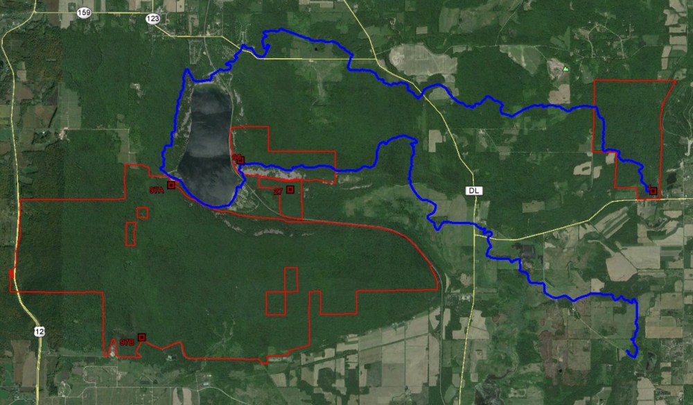
The state park has 29 miles of hiking trail encompassing a rather larger area. The East Bluff SNA protects the…you guessed it, East Bluff that rises nearly 500-feet above Devil’s Lake. It can accessed from either the north or south parking areas. From the north parking area, the East Bluff and East Bluff Woods trails pass through the SNA, the former near the edge of the bluff with nice views and the latter traversing through the forest, though more of your hike will be in non-SNA land than if you come from the other direction. From the south parking area, access is generally much steeper than form the north. The Balanced Rock and Potholes (very steep!) trails lead to the bluff top and connect with the East Bluff trail. The route from the south parking area to the top of the bluff and the southern segment of the East Bluff trail double as part of the Ice Age Trail. The IAT continues south around the lake, skirting the South Bluff/Devil’s Nose SNA and then along the West Bluff and through the north shore area before leaving the park. Continuing east along the southern edge of the East Bluff, the IAT exits the SNA and continues through other park lands. If you continue along the IAT from the north shore area, you will eventually come to Parfrey’s Glen, Wisconsin’s first SNA. The map below shows SNA’s in red and the IAT in blue.
This area of the park is where you are likely to find some of the greatest concentrations of hikers. On my visit it seemed to be much more popular than the non-SNA West Bluff, perhaps because that bluff is slightly more removed from the parking areas and is not quite as obvious to reach. As mentioned, the views are spectacular from the bluff. There are several interesting rock formations along the way including Devil’s Doorway, Balanced Rock, and the potholes along the Potholes trail, of course. Rock climbing on the talus slope below is permitted but doing so is at your own risk. All in all, it is a nice site to see a variety of geologic features, great views, and calm forest walk.


More of my photos (and full-res) from East Bluff can be viewed here.
Additional Information
| SNA # | 98 |
| County | Sauk |
| Natural Communities / Geology |
Talus Slope, Southern Hardwood Forest, Glade, Dry Prairie, Oak Woodland, Bluff |
| Size (Acres) | 260 |
| Parking | Parking areas (paved) |
| Trails | Yes |
| Easy to Find | Yes |
| Best Seen By | Foot |
| Marked Boundaries | No |
| Ownership | Wisconsin DNR |
| Located Within | Devil’s Lake State Park (state park sticker required) |
| Dates Visited | 8.22.09 / 7.31.10 |
|
|
|---|


One Comment Add yours