SNA Visit Tracking

When you visit many natural places, you need to keep track of them (or at least I do). Here is how I do that presently.

Screenshot of my SNA spreadsheet.
This spreadsheet is used to keep tracking of visits, posts to Flickr and this blog, and basic SNA info such as the year a property became an SNA and the number of parcels of land that comprise it. Other things to add, time permitting, include the property owner and whether an SNA is dedicated or designated (the former is a more permanent form of protection than the latter).

Screenshot of county tracking spreadsheet.

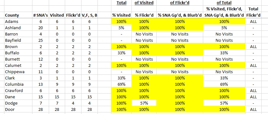
This spreadsheet is in the same Excel workbook as the previous one. If I visit a particular SNA, this spreadsheet takes note of which county that site is located in and updates the county visit statistics accordingly. Fun fact: Wisconsin has 72 counties, but 2 (Menominee and Kewaunee) do not have SNA’s. The entirety of Menominee County is an Native American reservation, but Kewanuee is just lonely I guess; it borders Door County and its 28 SNA’s to the north. Also, South Branch Beech Grove SNA (Oneida County) and Two Creeks Buried Forest (Manitowoc County) directly border Menominee and Kewaunee Counties, respectively.

Advertisement

Leave a Reply

Fill in your details below or click an icon to log in:

WordPress.com Logo

You are commenting using your WordPress.com account. Log Out /  Change )

Twitter picture

You are commenting using your Twitter account. Log Out /  Change )

Facebook photo

You are commenting using your Facebook account. Log Out /  Change )

Connecting to %s